Sourcier: How to get easier access to data thanks to a search engine?
The Search-Based Applications (or SBA) have a one of a kind software and ergonomic approach. When putting the search engine in the center of the exchanges and functionalities, they bring solutions that are more suited and efficient than classical distribution processes. Acting as an Information hub, aggregating data from heterogeneous sources, they provide a pertinent alternative for distributed systems and particularly for French Water Information System (WIS-F).
On the other hand, when they are not well mastered these applications may lead to many wrong shortcuts. When offered access to a too complex interface and decorrelated from the indexed data, users are led to make contradictory requests ending up to void and frustrating results. Following a similar path, lack of guidance (such as suggestion mechanisms) may discourage users browsing the website out of curiosity. Finally, it is useless to mention performance issues which, if they are deficient, would wreck the efforts put on other aspects.
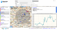
This is how the R&D project, Sourcier was created in collaboration with Exaleada software company with data index and data mining expertise, though the solution CloudView, already implemented in other WIS-F applications. Sourcier is originally based on a case study related to underground water, where a prototype was created, offering simple access (3 clicks max) and fast access (3 secs max) to the tens of millions chemical quality analysis of underground waters of the ADES databank.
The first challenge was to implement a multi-dimensional research engine (measured parameter, concentration range, measurement period, spatial extent) on a large volume of data with no impact on the technical performances. The spatial extent, in its self, was a technological challenge since CloudView and in particular the indexation engine did not include any spatial extender.
Besides, the final deliverable was supposed to provide a first level of understanding of the following questions, related to ergonomics and user-friendly features: how to avoid losing a user who is not yet familiar with underground water quality elements? How to prevent null answers or unsuccessful queries? Also: how to prepare and present data in a way that masks the complexity issued by modelling and scientific expertise?
This project is now officially over. Yet, it lives on through its many outputs:
- First, though its prototype, which was successfully implemented and provides the answers to the initial technical and ergonomics aims. This is the reason why partners have jointly decided to keep it going for several years. However it is still based on the data from the 2009 ADES bank, so its exploitation, regarding distributed data, does not meet scientific research requirements.
- Secondly, the development of a geographic indexation module compatible with CloudView, was only fully integrated in the next versions than the one used in the initial “Sourcier”.
Dernière mise à jour le 18.05.2020


